
Hiking
Hiking Trails in the Siuslaw Region
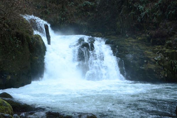
Sweet Creek Falls Trail
Adventure begins from multiple trailheads at the dog- and family-friendly Sweet Creek trail network in Mapleton. Ten miles from highway 126, the scenic drive through temperate rainforest is half the adventure. Summer provides warm days and a chance to take a dip in one of the many pools of the stream, though parking and trails can become congested on the weekends. The water is calmer and slightly warmer in summer and autumn, with brilliant foliage in the latter. Visit in winter or spring to see the falls in their most dramatic fashion. High water volumes and a lack of deciduous leaves allow for spectating of many tributary falls as well. A valid recreation pass is required for vehicles.
0.8 to 5.2 miles (network) | Lower Siuslaw River

Pawn Trail
A short loop trail provides easy access to old growth forest along the North Fork Siuslaw River. Grab an interpretive brochure at the trailhead (or download at the link below) to learn more about the flora, fauna, and natural history of the forest as you stroll along the mostly level path. Families with young children and those with physical challenges often take advantage of this casual hike. The trailhead is most easily reached from Florence by following the North Fork/Upper North Fork Road for approximately 17 miles, especially for adventurers who prefer pavement. A valid recreation pass is required for vehicles.
0.8 mile (loop) | North Fork Siuslaw River
Chief Siltcoos & Lagoon Trails
Adjacent loop trails, with trailheads on the Siltcoos Beach Access Road, offer a chance to explore the coastal forest ecosystem of the Oregon Dunes National Recreation Area. The Lagoon Trail threads between an oxbow slough flush with bird life and the Lagoon Campground. The constant activity of the campground may be both distracting to hikers looking for solitude and comforting to those explorers who prefer not to wander far from the road. A quieter option, the Chief Tsiltcoos Trail climbs small bluffs abounding in salamanders, rough-skinned newts, and ubiquitous snails and banana slugs. Both trails accommodate fungal foragers following rainfall. Beach access is available at the end of the road. A valid recreation pass or $5 fee is required for vehicles.
.8 miles | Oregon Dunes National Recreation Area
Threemile Lake North Trail
Trail begins in an old conifer forest and ends at the beach. The trail provides vistas of freshwater lakes, wet areas within the forest and ocean waves. The trail wanders through a spruce forest with substantial tree size, stops at the serene Threemile Lake and ends at the ocean beach. Always use caution on the beach. Watch for sneaker waves, know the tide schedule and stay away from logs in the surf or on wet sand. Look out for deep water and strong currents.
3.3 miles | Oregon Dunes National Recreation Area
Tahkenitch Dunes Trail
Combine this trail with the Threemile Lake North Trail into an extended single loop trail of 6.5 miles. Trail goes through a mile of conifer forest, opening onto the dunes and views of the ocean. The trail then re-enters onto a smaller stand of shore pine and ends at the ocean. Always use caution on the beach. Watch for sneaker waves, know the tide schedule and stay away from logs in the surf or on wet sand. Look out for deep water and strong currents. Snowy Plover restrictions are in place from March 15 - September15.
2.2 miles | Oregon Dunes National Recreation Area